Thursday, October 9, 2014

USARA National Championship 2014 Recap


Event 1: Run / White Water Boogie Board

-          We were the second team up the ski slope, right behind Technu to start the boogie board section. Each team must complete 3 loops around the white water course to receive credit for this section. Dan completed the first loop and switched off with Earl. Earl completed the remaining two laps. His impressive river skills enabled us to slightly pull ahead of Technu. We ran back down the ski slope to transit onto our bike and begin section two.


Event 2: Bike

-          CP’s 2-5 could be collected in any order in Bike. These points we located on the mountain bike course Southwest of Wisp resort. We had little trouble finding these points. After completing this section, we made our way back to Wisp resort (TA/2) to begin the 3rd event (Paddle / Run Orienteering).


Event 3: Paddle
 This part of the race offered teams the ability to begin to strategize. Option 1 was to collect CP’s 7-10 on the paddle before continuing onto the Orienteering section. The start of the O course was located at CP 10, located in Deep Creek St. Park, due west of Meadow Mountain Run. Option 2, was to paddle straight to CP 10, complete the O – course, then proceed to punch CP’s 8 and 9, which were located on the southernmost end of the lake. Or teams could skip these points all together and paddle back to the CP 7 which was the paddle put in, located at Mchenry Marina. Since it was early in the race, we decided to pursue all available paddle points. There was a strong headwind during the majority of the paddle. We thought that once we collected CP 8 and 9 that we could then use the tail wind to our advantage on our way to the start of the O-course (CP10).  This plan did not work out. 

The wind died down shortly after we punched CP 9 and paddling towards CP 10. Teams that elected to complete the O-course first had the advantage to collect CP 8 & 9 later since the lake had calmed down. We chalked this up as bad luck, nothing we could have done to predict this. The O-course went rather fast. Our time to collect CP’10-15 took approximately 1:45. GOALS has the fastest time with 1:43.  Once we collected all 5 CP’s we headed back to the Mchenry Marina. Dropped the boats and ran back to Wisp Resort to punch CP 16 (TA/3).  We left TA/3 shortly after 6:00 PM to begin the next biking section.

Event 4: Bike

-          We traveled Northeast via rt. 219 until we reach Savage River State Forest. This was located approximately 20k from Wisp Resort. We punched CP’s 17-20. Based on the location of the points, there were not too many different options to attack these points. Once we collected all 4 CP’s we continued East over to New Germany State Park to collect CP’s 21-25. We were moving rather well until we reached CP25. We had two options: Double back the way we came and ride an extra ½ hour to CP 26 or bike wack down the hill to a road that was clearly shown on the map and possibly save a significant amount of time/distance. We decided to bike wack downhill to the road. When we reached the road, we found it was completely washed out and un-rideable. This meant, we faced a 2K hike-a-bike East until we could reach a hard road. This decision cost us a significant amount of time and energy. Ultimately, we were able to reach CP 26, which was located southeast of CP 25 in New Germany State park; however were lost about 1hour due to the slow progress on the bike wack. Once we punched CP 26, we traveled south to CP 27, which was located at the intersection of the north end of the Savage River Res. (Big Run Road). We arrived at CP 27 at 4:00 AM, which was the start of the Score O-course.

Event 5: Score O

-          There was a possible of 10 points on this section. This was a very physically demanding section since all CP’s we located on hill tops that stretched Northwest along Big Run Road. Points could be collected in any order. We were able to collect 7 / 10 possible points before running short on time. We made it back to the TA at 10:00AM in order to provide enough time to make it back to Wisp Resort and attempt to collect additional points on the bike.

Event 6: Bike

-          We left the TA (CP 27) and traveled south to punch CP 28. We punch CP 28 located on the south end of Savage Rive Res, and traveled back to Wisp Resort via Spring lick Road. No other CP’s were available along this route and still provide us enough time to make it back to Wisp.

Event 7: Run O

-       We arrived at Wisp Resort at 1:02PM and punched CP 32. Since we had 58 minutes remaining, we made one last effort to collect CP 33, which was located at the top of the ski slope. We should have re-read the route of travel instructions. This was a run only. We biked to the base of the slope and ran up to collect CP 33, which was discredited. It did not make a difference in our place standings, but could have if we could have collected more CP’s.

Wednesday, August 20, 2014

TeamTOG: Lionheart AR Recap 2014

Team TOG - 2014 Lionheart AR Recap
American Adventure Sports recently hosted their annual 24-hour Lionheart adventure race on Saturday August 16th. We have each competed in this race in previous years and every year Doug Critzer (race director) and his crew comes up with new ways to challenge racers and run an exciting course.
The night before the race was team check-in. We received the maps as usual but when we went over to the master map to transpose the CPs we knew that the 9 listed on the map was not the whole race. It was a very straightforward and fast course beginning at the Sugar Loaf sledding hill and a run to the paddle put-in at Confluence, PA with 3 CPs on the way. After the paddle there were three more CPs before returning to the Sugar loaf sledding hill for a transition and the second half of the race. What we didn’t know was where/when the bike/orienteering section(s) were going to be.

Saturday 8:00am
All the racers took off as one bunch up a fairly wide trail to the first CP, which was only about 1km south of the start but required some bush whacking down a stream reentrant that quickly thinned out the crowd. Team AAS made it to CP1 first but we quickly followed with teams GOALS ARA and Odyssey. We jumped onto a dirt road along side team Odyssey that would lead us to a trail taking us to CP2 which was a beautiful 1200ft high lookout overlooking the Youghiogheny river. From here we were able to link up with a pipeline and fire tower access road down the mountain to the riverside for the 3rd CP (about 10km). This left a fast 3km push up the river trail to the boat put-in. We arrived only about 5 min behind GOALS and AAS so we knew we needed a fast transition (about 2 minutes and we were on the water).

Paddle: 10:06am (16km / 10 miles)
This was a 16km paddle with one CP on an island about half way through. We decided to have Matt and Nick in the two-person boat and Amber in the single being towed behind. We could see teams AAS and GOALS ahead of us. We met up with both GOALS and AAS at the island CP but they were back on the water a few minutes ahead of us. The river was still a little low considering the controlled dam release, which caused all the teams to battle some rocks. During one of the faster water portions of the river we had to serpentine around some rocks to avoid getting stuck but Amber’s boat spun sideways and flipped her into the water. Luckily it wasn’t in dangerous part and she popped right back up.  It took a few minutes to gather up her paddle and get her back in to boat.

Out of the Water: 1:00pm
From the boat take-out we stacked two boats and carried the equipment to White Water Adventures, about 0.5 km away. From there we had specific trail directions on how to run to the next CP with a surprise waiting. Once we got there (about 30 min behind AAS and 10 minutes behind GOALS) we saw a slack-line stretched across a creek bed leading to a rappel over cucumber falls. This was a real highlight of this race! Although it was a lot of fun we had to keep moving to the next CP, which was about 3km up a nearby stream with another waterfall view where we ran into GOALS while having some trouble finding the CP. After a little searching we figured we needed to keep moving down the trail and found the CP.
We decided that the fastest way to the next CP (located a the start/finish) was to cross the stream on top of the waterfall and bushwhack 0.2km up hill to a trail that would lead us CP/bike transition.

 Second Half / Bike Orienteering: 3:56pm
Once we got back to the starting line we were instructed to plot an additional 8 points that were worth a total of 21 points and could be completed in any order (Rogaine). We hurried to plot the points, plan a route, and get our packs ready. We knew we had plenty of time to clear the course but there were a few different options how to attack the points. We decided to attack 3 points that were closer and required a bushwhack down a long draw to the base of some cliffs but would put us on a rails-to-trails path that would allow us to move fast to the next set of CPs. We had a miss-cue on the 3rd point at the bottom of the draw that kept us looking around in the woods longer than expected.

Once we got down off the draw we jumped on the rails-to-trails path for a 20km ride to next group of CPs. We hit these points without a hitch attacking each from the rail-trail. We decided the fasted route back to the last set of three CPs was to back track past where came from but since it was dark we would be able to move much faster on the gravel and hard-top roads this route featured.
The last three points were on a fast loop that we figured would be the easiest to find at night. The loop allowed us to travel on gravel roads except for a small bushwhack section to cut over to another road. During the bushwhack we were welcomed by a trail that wasn’t on the map that minimized the bushwhacking but took a longer way around to the last CP. Once we punched the last CP we jump on the bikes and pushed up to the finish where we finished just 20 minutes behind GOALS. We ended up with a 4th place finish behind AAS, Odyssey, and GOALS.


Finish: 5:06am (Total Time: 21hrs 6min)

Tuesday, August 12, 2014

GOALS KG Memorial Race Recap: Team TOG

GOALS Krista Greisacker Memorial Adventure Race is a 12 hour adventure race held in the Appalachian mountains of Pennsylvania. This year the race featured a linear course spanning from the town of Tamaqua to Kempton PA with a true single-track mountain bike course, two bushwhacking intensive orienteering courses, and a canoe leg in between. The course was fairly straight forward point to point navigation with some adventures thrown in between.

The race began with a prolog where racers had to run 100yard to a parking lot and find their bikes with one teammate racing on foot to the first CP. We came out of the prolog in third and raced to the beginning of the mountain bike course. The section was an intensive 10 miles of single-track designed specifically for some fun mountain biking and favored the more experienced riders. During this bike course we stopped to help another race team fix a broken rear derailer which turned out to be unsuccessful. We came out the single-track course a little behind but pushed fast toward the orienteering courses about 10 miles away getting two CPs along the way.

The foot orienteering course was split into two sections that began at the bottom of a ravine with each section requiring a 400 - 500ft steep climb to begin. We chose to start with the "A" course which was more spread out. The O-Course required intense navigation and a lot of bushwhacking. We cleared the A course but only had time to take one CP from the "B" course before riding down to canoe put-in.

The canoe section was not the fast paddle the racers were hoping for. The water levels were quite low and required almost as mush time out of the canoe pushing as time paddling in the canoe. After some time on the water the takeout came as welcome relief.

The last section of the course required racers to navigate their way to the base of the north side of Hawk Mountain where we punched another CP and one out of three optional points due to time lost on the water. From there we had to bushwacker a fairly linear line up over 800 feet in elevation to the ridge line punching one CP along the way and one at the top (Dan's Pulpit on the Appalachian Trail). The route down the south side of the ridge line took a lot rock jumping and good navigation to meet up with an old Jeep trail that ran through the final two mandatory CPs. Once the final CP was checked we had to hustle about three miles to finish where we placed 2nd in the 3-person coed division.

Thanks to GOALS ARA for a great job incorporating some great riding, orienteering, and sights into this race.


Thursday, July 24, 2014

MS 150 Keystone Country Ride


This past weekend 12 members from our Team Toyota of Greensburg (Team TOG) took part in the MS 150 Keystone Country Ride! This event supports people with Multiple Sclerosis. Our good news is that Team TOG raised $5,000 for this event!! The overall amount that was fundraised was $329,078. The MS 150 Keystone Country Ride takes place at Hollidaysburg Area Senior High School (near State College). The 2014 course was over 150 miles long and consisted of back roads and rolling hills of State College, Pa. Every 12-18 miles there was a rest stop with food and beverages available for bikers along with bike mechanics. There was also the infamous “Cookie Rest Stop” and an ice cream cone from the famous “Penn State Creamery”! For those of you who don’t know the Penn State Creamery is a legendary ice cream shop at Penn State College. If you every go to visit the college you have to grab an ice cream cone, you just can’t pass them up.  After the ride there was a festival for all of the riders to enjoy afterwards. This was a great time and we can’t wait to do it next year!


Tuesday, July 15, 2014

The Adventurous Interview Part 3: A Sit Down With Team Toyota of Greensburg Member Matthew Darnell

Hello everyone! My name is Emily Terrick and I am a Marketing intern for Toyota of Greensburg. If you’ve been following Andrew’s blog posts, you know we’ve been interviewing Team TOG members.

Today's featured athlete is Matthew Darnell. Matt is finishing his PhD at the University of Pittsburgh in Sports Medicine Nutrition. He has been adventure racing since 2010. Read on to find out more about Matt and to see what adventure racing is!

Emily Terrick (ET): "Have you always driven a Toyota?"

Matthew Darnell (MD): "My first car was 1990-Toyota Camry. I had one car that wasn’t a Toyota but that got totaled and since then I have always had Toyota’s."

ET: "What model Toyota do you have and why?"

MD: "I have a 2003 Toyota Tacoma. I like Toyotas because they are dependable. I like the small pick-up truck because it is perfect for driving in the city or back roads and trails. This truck helps me do all my favorite activities like kayaking, mountain biking, construction etc."

ET: "When did you start adventure racing?"

MD: "My first race was in the summer of 2010 and it was a 24 hour race."

ET: "What is your skill in adventure racing?"

MD: I keep track of diet. I am a pusher as well. I like to keep everyone on the team motivated to complete the race. I also assist in navigating and pace tracking."

ET: "What is adventure racing?"

DM: "Adventure racing is a unique sport that in order to compete in the elite division, you have to race with at least one female on the team. It involves multiple disciplines like orienteering/navigating, running, mountain biking, paddling, climbing, and repealing. Everyone on the team works together to navigate to multiple check points throughout the race course.

ET: "What is your favorite course you have raced?"

DM: "I like all of them, but my favorite would be the National Championship in 2012 at Catskill Mountain in New York. It was a 30 hour race and we took a bus to the middle of nowhere and at the end of the race we repelled off a 70+ foot waterfall."

ET: "Do you have a job or going to school anywhere?"

DM: "I am currently finishing my PhD in Sports Medicine Nutrition and work at a Human Performance lab at the University of Pittsburgh. This September I will be an assistant professor at the University of Pittsburgh working as the director of the Wellness and Human Performance Master’s program."

ET: "Were you friends with everyone before asked to form Team TOG?"

DM: "Nick and I were friends and started to do adventure racing together. And then Nick was friends with Amber and Lizzie and we all became friends and started racing together about 2 years before joining team TOG.

I enjoyed talking to Matt about adventure racing because it was something new to me. I learned a lot about adventure racing from this interview. I thought its was really awesome that he got to repell off a 70+ foot waterfall! I can't even imagine doing something like that! I would like to thank Matt for taking time out of his busy schedule to do this interview with me.


Tuesday, July 8, 2014

The Adventurous Interview Part 2: A Sit Down With Team Toyota of Greensburg Member Liz Bronson

Hello Team Toyota of Greensburg Blog Readers. My name is Andrew Gauntner. I am a Marketing Intern at Toyota of Greensburg. My co-intern and I will be posting some interviews we have done over the past couple of weeks to the Team TOG Blog. Below is the second interview in a series of four! I hope you enjoy them!

If you don’t already know, Toyota of Greensburg has partnered with American Adventure Sports (AAS), an adventure race production company based in Greensburg, PA. Adventure racing is a relatively new sport and has recently become more popular. Adventure racing is not your typical race that you see on a track. It is distinct in that it involves traveling through the wilderness and not having a set route. You have to find your way to the finish line using what adventure racers call orienteering. Orienteering is the process of using a map and compass to find your way to the finish (No GPS allowed out there!). Most adventure races are 24 hours or longer and include different athletic disciplines.

Today’s featured member, Liz Bronson, studied athletic training at Ithaca College, and currently works as a certified athletic trainer in Pittsburgh, PA. Although she was a sprinter on Ithaca’s track team, Liz transitioned to longer distances after becoming involved with the Pittsburgh Marathon.  She was introduced to adventure racing in 2011, when she competed in the Lionheart race (and mountain biked for the first time). Liz is drawn to the sport because it constantly challenges her to push her physical and mental limits.

Andrew Gauntner (AG): "I heard that all for members of Toyota of Greensburg happen to drive Toyota vehicles. Which Toyota do you currently own?"

Liz Bronson (LB): "I currently drive a Toyota RAV4."

AG: "Great to hear! Why did you choose the RAV4?"

LB: "I chose the RAV4 because it is a SUV, but it’s not too large. I looked at the RAV4 and the CRV and one reason I chose the RAV4 over the CRV is because I like the side swing door because it still allows me access to my trunk even with my bike on the back."

AG: "What are some of your favorite features of your RAV4?"

LB: "I like that the car is really a total package. It is built well, handles well, and has good snow traction. I also like that it feels more ‘off roady’ than other small SUVs. I also like that it has fog lights and good gas mileage. I just like the car in general."

AG: "I’m very glad to hear that you like your RAV4. When did you start adventure racing?"

LB: "I started adventure racing in 2011 when I ran the Lionheart race."

AG: "Why did you start adventure racing?"

LB: "I started adventure racing because a co-worker approached me and asked if I would be interested. I agreed and we ran the Lionheart. It was a grueling 24 hours and I felt horrible afterwards, but after about a week, all I remembered was the fun stuff, and I was hooked."

AG: "Interesting. I want to show people that adventure racers can come from all walks of life. Do you have a full time job and, if so, what is it?"

LB: "I am an athletic trainer at UPMC."

AG: "What is your favorite adventure race discipline?"

LB: "My favorite discipline would be foot orienteering, but my strongest discipline would be walking uphill."

AG: "What is the most exotic place you have raced?"

LB: "The most exotic place I have raced is Belize in the Maya Mountain Adventure Challenge. It was absolutely breathtaking. It was the perfect combination of people doing the race and the people of Belize. It was really the perfect package."

AG: "What is the most challenging race you participated in?"

LB: "Mentally the most challenging race was the East Coast Adventure Racing Series (ECARS) championship in 2012. It was an 18 hour race that started at midnight. Usually, once daylight breaks, you are almost done. Not with this race. We also got a little messed up with the navigation. The most physically challenging race was the Yough Xtreme Adventure Race this past April. It was only a 10 hour race, so the pace was extremely fast. You had to keep moving quickly. In Belize, you didn’t run a step. At the Yough, you had to."

AG: "Wow! That sounds very difficult. If someone reading this wanted to start adventure racing, do you have any advice for them?"

LB: "My advice would be start slow unless you are in very good shape. Be open to feeling like you are going to die and be comfortable being uncomfortable. You also need to be persistent."

AG: "Thanks for the advice. Obviously, you need to train. What is your training schedule like?"

LB: "We have to maintain a certain level of fitness. I usually train with my fellow team member Amber Clites. We take runs through Frick Park and do some weight training. Before a race, we usually try to get together and practice as a team."

AG: "It’s great that you can train with a friend from the team. One last question: What do you enjoy best about being on an adventure racing team?"

LB: "I like the team dynamic. It is one that you will never find in an optional activity. Everyone has their job to complete and you work together and feed off each other. It’s a great, friendly community. It is also awesome to watch people go out into the wood and work together."

It was truly a pleasure talking to Liz and learning more about her and adventure racing. I have learned a lot through my interviews with her and Nick Heebner. Adventure racing really does sound like an awesome sport to get involved in. I would like to thank Liz for being an awesome interviewee!

*Team TOG is an adventure racing team sponsored by Toyota of Greensburg. The team consists of four members. Each of them know how to compete in all the disciplines in adventure racing, however each has a specific discipline they specialize in. Fun Fact: All four members happen to own Toyota vehicles.


Thursday, July 3, 2014

GOALS Cradle of Liberty Race Report

GOALS Cradle of Liberty
Great race. We could have easily had 5 more CPs (1 due to communication error). We moved efficiently for the first 17 hours with really no mistakes. The last 3 of those 17 really hurt us though for the next 4. Earl and I were falling asleep, we made a few errors, lost focus on the race, and caught a bit of bad luck. We ended up recovering and finished the race smart.
Earl was nursing an injury but was still able to move effectively except riding on rocky ST trails. I think the course might have even been clearable (5 more CPs, 10 total) if Earl was fully healthy and we didn't have that low point.


Abby and Brent did a great job and put on a great race. Organization and communication was spot on. They also do an excellent job of taking you to the right spots on the course and requiring a fair amount of navigation (some might say too much). The night trek was a bit much for beginner teams.

Saturday Jun 28

8 AM
Orienteering 20:00 3 mi
Prologue - Team O-Relay
Each of us had about a 1 mile run to a CP, a waterfall, and back. Kristin nailed her section! (by taking the first leg and following Jason from GOALS)

Paddling (Canoe 3p) 4:00:00 16.4 mi (4.1 mph)
Swataraaaaaa (Ninja) Creek
Started out for the first 2 miles having to get in and out of the boat to push, portage and walk down the creek. After that it was mostly clear enough to paddle the entire way.
There were 8 CPs total. Earl did the Nav for this. We slightly overshot 1 CP and overshot another along with the rest of the leaders. We finished the paddle within minutes (+ and -) of the rest of the leaders.

12 PM
Mountain Biking race 2:30:00 [4] 18.3 mi (7.3 mph) +1225ft
Mostly rail trail and road with a 4 mile singletrack section. We collected several points along the way. One was a random cabin with a bonus clue and CP that Brian had forgotten about. We missed out on this due to this communication error. The singletrack was fun except for when Brian took a spill. Brian was lead nav.

3 PM
Orienteering 3:00:00 8.23 mi (21:52 / mi) +1452ft 18:44 / mi
Excellent orienteering course. Only one minor mix up at the top of the ridge. Checked one direction, then turned around and went back the other, then finally turned around again and went a little further the other way to find the control. The trail we had planned to take up the ridge wasn't there but the woods were clear enough to shwack just as fast.
This loop had some excellent locations. We came across several freshwater springs to cool us off and refill with fresh, clean and cold water. Next up was a 100yd boulder field. Immediately followed up with a random 70ft high, 100yd long ravine. Great CP locations! Awesome Trek!
Both Brian and Earl were nav since we had two maps!

6 PM
Mountain Biking 1:30:00 11.0 mi (7.3 mph) +1114ft
Left Lebanon doing a hike-a-bike. Followed that up with a short rail trail ride, a major climb and major descent (80kph) into Tower City. Stopped for a quick slice of pizza and filled our water before heading to the TA where our bins were waiting.

7 PM
Orienteering 6:00:00 10.65 mi (33:48 / mi) +1387ft 30:05 / mi
This was by far the hardest leg of the race. Off trail travel at night always is. We started the trek thinking we could still clear the course if everything went as planned so we weren't ready to drop points yet.
We were able to get the first two points in daylight and the third as the sun set. These points were pretty straightforward and allowed some traveling on roads. We were still good on time. After the 4th CP we started a 5 mile shwack through knee to chest high blueberry bushes. We had two 1/2 mile trail breaks. Otherwise both Earl’s and Brian’s eyes were glued to the compass to stick to our bearings. Only stopped looking for 5 minutes when we did a small loop back to a road crossing. We then re attacked from a different spot on the road.
This trek was very draining mentally and physically but we really did nail it. Still took 2 hours longer than we were hoping for (2 hours for the first 3 CPs and 4 hours for the last 4). Brian had mapped a few extra roads from a FS map without contours that we never found that would have helped. Aerial seems to say some of them existed and that we could have used them if he had known exactly where they were.

Sunday Jun 29
1 AM
Mountain Biking 6:30:00 26.0 mi (4.0 mph) +2789ft
Decided to drop one big cluster of CPs on this bike leg and 2 more scattered CPs. As we started Earl had to give me back the map since he was falling asleep. Brian wasn't doing much better as he rode right by Kristin without noticing she had stopped at the trailhead of our next turn.
Shortly after that we ended up on a super rocky singletrack. Earl wasn't able to ride because his shoulder was still sore from his crash 2 weeks ago so we walked the mile long technical rocky trail. Would have been faster to take the long way around on doubletrack and we would have gotten another CP. There was really no way we could have known the trail condition though.
Had trouble on the next CP. It was in a steep reentrant. We had to go in and out of the reentrant to find it. Missed it on the way down. Then checked to make sure we had the right reentrant. Then found the CP on the way back up. Kristin was really the one powering us through this rough spot.
It got much more straightfoward after that. Followed doubletracks along long high ridges to capture more CPs. Skipped another because time was running short. Dropped down the ridge and then monster climb back up the next one to TA.

8 AM
Orienteering 20:00 0.5 mi (39:59 / mi)
Box Car Rocks
"Orienteering" section without maps. Just pictures and directions. This was a good way to force us to spend some time here and enjoy the feature without being cheesy. Awesome scenery. A nice little break too. Maybe too much of one.

Orienteering 45:00 2.5 mi (18:00 / mi) +389ft 15:41 / mi
Went to collect a few close CPs before leaving to make the finish cutoff. Got 2CPs quickly then headed for another 2 with hopes of getting at least one. As we approached the pond Brian encountered 2 rattlesnakes that surprised him one at a time at the last second running across some rocks. The second one was the only one who hissed and rattled. He was maybe a 100yds away from the pond but still not sure where the point would be and we were running low on our self-imposed cutoff so we took that as a sign to turn around.

9 AM
Mountain Biking 25:00 6.0 mi (14.4 mph) +420ft

Bike to the finish on roads. We left right at our self-imposed cutoff. 2 descents and 1 climb. Climb was about half the size that Brian thought it was (didn't look close enough) so we made it to the finish with 20 minutes to spare. We didn't think we'd be able to make it in under 30, but we did.

Monday, June 30, 2014

The Adventurous Interview: A Sit Down With Team Toyota of Greensburg Member Nick Heebner

Hello Team Toyota of Greensburg Blog Readers. My name is Andrew Gauntner. I am a Marketing Intern at Toyota of Greensburg. My co-intern and I will be posting some interviews we have done over the past couple of weeks to the Team TOG Blog. Below is the first one! I hope you enjoy them!

Recently, I had the opportunity to interview a member of Team Toyota of Greensburg’s (TOG). Toyota of Greensburg has partnered with American Adventure Sports (AAS), an adventure race production company based in Greensburg, PA. Adventure racing is a relatively new sport and has recently become more popular. Adventure racing is not your typical race that you see on a track. Adventure racing is distinct in that it involves traveling through the wilderness and not having a set route. You have to find your way to the finish using what adventure racers call orienteering. Orienteering is the process of using a map and compass to find your way to the finish (No GPS allowed out there!). Most adventure races are 24 hours or longer and include different athletic disciplines.

Team TOG is an adventure racing team sponsored by Toyota of Greensburg. The team consists of four members. Each of them know how to compete in all the disciplines in adventure racing, however each has a specific discipline they specialize in. Fun Fact: All four members happen to own Toyota vehicles. One of the four members of Team TOG is Nick Heebner. Nick received his undergrad degree from Penn State in Athletic Training which is where his love in trail running, mountain biking, and just being in the woods began. While looking for something more challenging and interesting than typical road and trail events he decided to try adventure racing by competing in the 24-hour LionHeart race. He was hooked after that and found himself competing in the USARA National Championship just two years later. It was great talking to him and learning not only about himself, but more about adventure racing as well.

Andrew Gauntner (AG): "I understand that you, as well as all of your teammates happen to own Toyota vehicles. Which one do you currently own?"

Nick Heebner (NH): "I currently have a Toyota Tacoma."

AG: "Why did you choose the Tacoma?"

NH: "I chose the Tacoma because it is a smaller truck. I wanted a smaller truck because it can be difficult to get a full size truck on some of the trails we race on."

AG: "What are some of your favorite features of your Tacoma?"

NH: "I like that it has a very capable four wheel drive system and all the room in the bed for equipment. I have a regular cab, so there’s a TON of room for equipment back there."

AG: "I’m glad that you like your Tacoma. When did you first start adventure racing?"

NH: "I first started racing in 2010, so I have been doing it for four years. However, I have been doing the different race disciplines for a while."

AG: "Why did you start adventure racing?"

NH: "I started racing because I like the competition and the thrill of it. I tried one of the AAS events and loved it. I also like the fact that when I race, I am being challenged."

AG: "I want to show that adventure racers come from all walks of life. Do you have a full time job, if so, what do you do?"

NH: "I am actually working towards my doctorate in sports medicine at Pitt (University of Pittsburgh)."

AG: "What is your favorite adventure race discipline (biking, swimming, running, etc.)?"

NH: "Adventure racing actually has four disciplines: a water activity (kayaking, canoeing, rafting, etc.), running, mountain biking and orienteering (navigating). My favorite activities would be mountain biking and orienteering. Orienteering is actually my strong suit and I am Team TOG’s orienteer."

AG: "What is the most scenic place you have raced at?"

NH: "The most scenic place I have raced at… I would have to say it would be in the Catskills Mountains in New York."

AG: "What is the most challenging adventure race you have participated in?"

NH: "The most difficult race I have participated in would have to be the US Adventure Racing Championship in the Catskills in New York. Typically, the races are in loops, so you can leave some equipment in your truck so you aren’t lugging 24 hours’ worth of gear with you. The championship is what we call a linear race. You start somewhere and then end somewhere else. So, we were unsupported. We had to lug 30 hours’ worth of equipment with us. It was challenging."

AG: "That’s really interesting. If someone wanted to start adventure racing, do you have any advice for them?"

NH: "I’d say take it easy at first. Don’t jump into a 24 hour race. Do a shorter race and build up to it. I’d also recommend working with a team or friend. It is a lot more enjoyable, and you feed off each other’s energy."

AG: "Thanks for the advice. Like all other sports, you need to train. What is your training schedule like?"

NH: "For the most part, you train on your own. You go to the gym and bike or run. You have to keep your fitness level up. As far as training as a team, we try to meet at least once a week to work out the technical details, like transition from bike to running and things like that. Another thing you have to watch is your nutrition."

AG: "My last question is what do you like best about being on an adventure racing team like Team TOG?"

NH: "I like the companionship with each other. It’s also a great way to meet friends. And you have to rely on one another when you’re in a race. You are together for 24 hours and you are trying to place well. You HAVE to trust one another and rely on each other to finish well."

Nick’s answers were very interesting to me and I found out a lot about adventure racing. It sounds like an awesome sport to get involved in. He also told me that there are many places locally (within an hour or two) of Greensburg that hold adventure races. One of the popular spots for adventure racing locally is Ohiopyle. On June 21 & 22, some Team TOG members competed in AAS’s Pyle Run & Ride. Toyota of Greensburg was there as well with our TOG Tundra! If you would like to learn more about adventure racing, you can visit AAS’s website at www.americanadventuresports.com. I would like to thank Nick for being an awesome interviewee!

Stay tuned for more Team TOG profiles!


Wednesday, May 21, 2014

Odyssey Wild Wonderful Race Report 2014


Saturday May 17
Event: Odyssey Wild, Wonderful 24 Hour AR
Writer: Bryan Mayer & Kristin Eddy 

The team had a strong race. We moved fast and in the right direction almost the entire time. Urgency suffered a bit since GOALS was no longer elite and Odyssey had to go unofficial early on in the race (Mark punctured his calf with a stick). Probably would have been better if GOALS hadn't told us. We still moved fast but stopped for pictures and maintenance a little more than usual. We had a great time though and saw some great scenery. 

Brian: We executed everything well and worked well as a team. I made one wrong choice in route decision but lost minimal time. Also had trouble finding one tough CP in the dark and misplotted another. We triple checked the one that I thought was misplotted and still didn’t realize my mistake. Luckily it was the closest point to the TA/finish so we were able to re-attack at the end without wasting too much time. If this had been in the middle of the course we would have been in more trouble. 

Kristin: Next time I will ask you if you are 110% sure (not just 100% : ) makes me laugh just thinking about it.

Brian: Ronny put together a great MTBO on the new Fayetteville MTB singletrack trails (Arrowhead) and we had a pretty epic trek back to ACE HQ from there. Lots of tough Nav. 

Kristin: The arrowhead trails/mtb section was one of my favorite parts of the race - always sweet to have great singletrack rolled into the race WITH challenging nav (which, by the way, you'd never know was challenging the way that Brian navs it: fast paced & nailed each point)

RECAP: Black (Brian) Blue (Kristin) 

8 AM
Paddle was cancelled. River peaked at over 16ft exactly at race start. This was the 22nd highest peak recorded. 0 is standard and 4-6ft is normal for this time of year. The rafting would have been EPIC. The river looked insane. Like a beast. I surely would have peed my pants if we had rafted it (though would have been fun i'm sure) SICK!!!!

Road Running 5:00 0.34 mi
LeMans start to bikes. We literally had to tell Dan to slow down (by the way, I said this to him more than once during the race!!! : ) He was a human rocket...for the entire race!!!
When I got to my bike I found that someone decided to lay it down in some nice poison ivy. Thank you.
Mountain Biking 40:00 4.58 mi +960ft
Climb to Fayetteville from “takeout”

9 AM
Road Running 40:00 4.6 mi
Run through Fayetteville to gather some CPs the lovely rhodo that blooms in the neighborhood between the park & town was in glorious full bloom...it is tri-color and almost as big as the house that it shades - remembered it from previous races, love that beauty.

10 AM
Mountain Biking 1:50:00 11.63 mi
MTBO on Arrowhead trails. Really well designed course section. Adding topo lines to the trail map and making the lines less than a 1/2 in thick iwould make this a professional MTBO. Yes, Ronny did a great job with this - FUN!!!

12 PM
Orienteering 9:00:00 24.2 mi
Long Orienteering section. Started with some points we had to plot around Fayetteville area. Had some amazing views and awesome scenery on this section. Did some of it with GOALS.racing alongside goals & the sweet spots of the controls were definite race highlights - overlooks, waterfalls, cool rock formations - really gorgeous.

On the first half (14-19t) I had to make a few minor recoveries (1-2 min) to each of the points. But no real problems. Still good navigation. (GREAT nav)

The second half was on ACE property. Struggled deciding when to get CP 22. Got it after 20 because I thought it would allow for more trail travel but I think in retrospect it would have been better after 24 (i tried to tell brian this, but he wouldn't listen, can you believe that?). Distance looked just as far but with the way we ended up leaving 24, 22 wouldn't have really been out of the way and would have been on trails. It was a tough call for me though so I don't feel too bad.

On our way to the last few points before we went to TA I started having trouble with the trail map. The labels are aligned E-W. I kept reading it as if they were N-S though so we were going the right way because I was following terrain but every time I looked at the compass I couldn't understand what was wrong. Befuddled me for two points until I realized the cause. Other than the 1 route choice only one 5 min error on the second half. Misread the map right before the attack to 24.

The pace was fast for this entire trek (yes it was...brian & dan kept steady gunnin', even with no sense of pressure...always nice to push simply to do our best - which i think we did!). Running whenever we could. Finished just after civil twilight.

9 PM
MTBO 2:40:00 12.25 mi +1300ft
Gathering the last points around the TA on bike instead of foot. Moved slow on these because it was dark, the trails are slow and everywhere, and we were starting to get tired.
Translated CP30 to the trail map incorrectly onto a parallel spur (the spur had a matching road with a unique shape, trail, and reentrant). When it wasn't there we thought Ronny had misplotted because the clue was off. We double and triple checked and then moved on. Next two points were clean and the trails to them were all good.
27 was difficult. Everyone had trouble with it. The planned attack was through private property. Had to back out and attack from farther away. On my way realized I mistranslated this point as well (just 1 reentrant off) but caught it in time. Had trouble finding the small (actually big but shallow) reentrant in the dark. Spent time looking in an wrong reentract full of briars before we reattacked from the top/private property. Still had to go all the way back to the bikes though. (low point of the race for many folks...lots of stories afterwards about this one!)

Had trouble finding an ACE trail on the way to the last point but got it and then rolled back to TA. When we got back we asked about CP30. Teams had apparently collected it so I checked one more time and noticed my translation error. The road is really what messed me up. Luckily it was only a mile or so away (but 400ft climb) so it was fairly easily attainable.
Orienteering race 1:30:00 2.3 mi
Trekking during MTBO

You are invited to view K mama's photo album: Team American Adventure Sports at Odyssey's Wild Wonderful

Monday, March 24, 2014

Team TOG: Amber Clites


Amber Clites studied Sports Medicine and Athletic Training at Denison University. She obtained her Master's from California University of Pennsylvania in Performance Enhancement and Injury Prevention.  Amber is currently the Head Athletic Trainer for the Pittsburgh Passion. 

After graduating college, Amber became involved in running and mountain biking.  In 2011, some friends suggested she participate in an Adventure Race, and she's been hooked ever since. Amber has participated in multiple 24-hr races and completed her first expedition race in 2014.

Tuesday, March 18, 2014

Technical AR Principles: Reading White Water

Reading white water – Learning how to read water is like learning a foreign language. Just as being relaxed and confident helps your cross-cultural communication skills, being relaxed will also enable you to pick the best routes through rapids while in your boat. A cool head allows you to clearly see obstacles, drops, and paths, whereas anxiety clouds your vision so that you see only an undecipherable mass of white froth.
Volume – Volume is the amount of water flowing past a point in the river per unit of time. In the United States, volume is almost always expressed in cubic feet per second (cfs), though occasionally it is given in some other dimension, such as cubic meters per second or cubic yards per minute. Depth gauges usually give the river level in feet, which is meaningful only if you know the individual river and therefore have a reference level or some other basis for understanding the relevance of the gauge reading.
A river’s power and speed always increase with an increase in volume. This usually means a difficult river will become harder with more water, but sometimes the opposite is the case. Sometimes high water causes a rapid to wash out and diminish in intensity. Experience on a particular river is really the key to knowing what to expect.
High water can create other problems. Flooding can cause trees to fall into the river or be picked up from the banks, increasing the danger to boaters. Extremely high water also tends to wash out most of a river’s eddies, those still-water havens behind rocks that are used for scouting and resting. On a difficult, flooded river, there’s little room for error. The water can be so powerful that your strongest attempts at maneuvering will be ineffective. If you want to learn all sorts of fun facts about rivers in flood, see William Nealy’s book, Kayak.

Gradient 
– River gradient refers to the average steepness of the riverbed. A rapid forms when a stretch of river has a higher gradient than the river’s average. A consistently steep river forms one very long rapid. Conversely, pools form where the incline levels out and the velocity of the water decreases. Most rivers are characterized as pool-drop rivers, with the riverbed alternating between relatively steep sections and level sections. These are the type of rivers most commonly run because they allow kayakers to rest after each rapid and provide them with an opportunity for checking out upcoming drops.
Gradient is measured in feet per mile. The most popular stretches for river running have gradients ranging from 10 to 100 feet per mile. The relation between gradient and difficulty depends, of course, on the individual river. Some rivers drop so evenly that they have miles of continuous low-grade riffles, despite high gradients. Conversely, a river with a low gradient may have miles of flat water with only one drop—a 200 foot waterfall.
As an extremely rough rule of thumb, most rivers that have gradients from 5 to 30 are usually Class 1 to 2 rivers, and gradients from 30 to 60 are likely to be Class 3 or 4. But as always, this depends on the particular river. Rivers with gradients up to 300 feet per mile are run, but only by experts, crazed maniacs, or those who can’t read topographical maps.


Water Velocity – Water velocity depends on where it’s being measured. In a straight section of river, the fastest current is in the middle where the river is deepest (See photo above). Water velocity decreases toward the banks and near the river bottom. Friction accounts for much of this loss of speed.

When a river bends, a majority of the water travels on the outside of the bend. This causes a deeper and faster channel to form on the bend’s outer curve. Because the inside of the bend has slower-moving water, not much of a channel is cut into the river bottom and the water is shallow. Often, the riverbank is higher on the bend’s outside. If there are waves going around a bend, then the biggest and best waves are where the water is deepest—toward the out bank (See photo to the right). But be wary—the faster water at the outside of the turn can undercut the outer bank, causing trees to topple into the water. In addition, the outside bank may be covered with overhanging brush. The water wants to take you there, but this is not where you want to go, unless you enjoy being slapped and snagged by shrubbery.
When water hits an obstacle (midstream rock, bank outcropping, and so on), it piles up on the upstream side of the obstruction and then accelerates as it continues downstream. Consequently, water speed is somewhat faster downstream and to the side of (but not behind) and solid obstacle.

Water speed increases past obstacle and near eddy line
Eddies – An eddy is any spot in the river where the water is moving more slowly or in a different direction than the main current. Rocks in the river are the most common cause of eddies, but eddies also form behind logs, bridge pilings, and bedrock outcroppings, as well as on the inside of bends and along the riverbank where friction slows the water. The water in an eddy can move at a slower speed than the main current, be completely still, or most often, move back upstream. An eddy’s character depends on the shape of the obstacle and on the level of the water. The faster the current is moving when it hits an obstacle, the stronger the current moving upstream behind the rock. This upstream current is always fastest just below the obstacle, making the eddy strongest near its top. The phenomenon of eddy water flowing counter to the direction of the main flow is caused by downstream water pulling eddy water downstream out the top of the eddy. Water from the downstream end of the eddy then moves upstream to fill the void. This leads to a constantly circulating flow of eddy water upstream and then downstream with the main current. A big powerful eddy on the side of the river with a lot of upstream current is, in essence, a giant whirlpool. The center is somewhat like the eye of a hurricane and is sunken in relation to the periphery.

Monday, March 17, 2014

Team TOG: Lizzie Bronson


Liz studied athletic training at Ithaca College, and currently works as a certified athletic trainer in Pittsburgh, PA.  Although she was a sprinter on Ithaca’s track team, Liz transitioned to longer distances after becoming involved with the Pittsburgh marathon.  

Liz was introduced to adventure racing in 2011, when she competed in the American Adventure Sports 24 hour Lionheart (and mountain biked for the first time).  Liz is drawn to the sport because it constantly challenges her to push her physical and mental limits.

Friday, March 14, 2014

Technical AR Principles: Holding Your Paddle

Technical Adventure Racing Principles #1 -- Holding Your Paddle

For the next few weeks, I will be posting general principles, methods, and suggestions on Adventure Racing disciplines. While an infinite number of volumes could be written on any one of the disciplines found in this sport, we have highlighted a few of the major points in order to help you develop yourself and your team as Adventure Racers. I am starting with Boat Basics and will eventually move on to Navigation, Climbing, and last, but not least, Biking.

#1. Holding Your Paddle

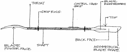
Curved and offset blades are standard on all performance paddles. Blade curvature imparts more power to a stroke than a flat blade, but it does make proper paddle control a little confusing at first. The concave side of the paddle is called the power face, and the opposite, or convex side, the non-power face. A paddle is always held so that during a forward stroke, the power face is pointed toward the stern, or the rear of the boat.


Because of the offset and curve, you need a strategy to make sure both blades enter the water with their power faces pointed back. Without such a system, one blade may slice through the water, offer no resistance, and possibly cause you to tip. Here’s the strategy: one hand, designated the control hand, maintains a firm grip on the paddle shaft and rotates the shaft within the other hand (the non-control hand) so that the correct blade angle occurs on both sides. Depending on the blade orientation, paddles are controlled with either the left or the right hand. Most paddles on the market are right-hand controlled. The control hand grips the paddle so that the wrist and forearm are at 90 degrees to the blade, with the power face pointed back. To place the opposite, non-control blade correctly, cock your control wrist out while maintaining the control grip. Keep in mind, for later reference, that there are times when you’ll want to cock your control wrist in. It’s not necessarily the case that left-handlers should automatically paddle left-handers should automatically paddle left-control. Some instructors go so far as to maintain that a paddler’s dominant hand should be the non-control hand.

Beginners sometimes mistakenly rotate the shaft partially within both hands. This causes blade disorientation because the permanent reference grasp the control hand is meant to provide, gets compromised. In addition, rotating the shaft within both hands makes it difficult to do some of the more precise strokes. If you’re having this trouble, try a visualization exercise and imagine that there’s super glue bonding your control hand to the shaft.

An oval shaft (instead of a round shaft), at least in the area of around the control hand, facilitates the correct positioning of the control hand and gives you more control over the blad angle with strokes such as the draw and the duffle (which will be explained in future posts). In addition, an oval shaft gives you a better grip and slightly more leverage with your control hand. If you already have a round shaft, you can make it oval in the control area by applying a thick line of Shoe Goo or some contoured fiberglass putty. You can even improvise an oval by placing a Popsicle stick on the non-power side of the shaft. A wrapping of electrical tape will secure the stick and provide a good grip.

Princeton Tec: Bike Light Review

Profile picture for Princeton TecThe EOS Bike is Princeton Tec's EOS headlamp that one can not only attach to your bike helmet but your bike frame.  Thus if you are doing some bike touring or over night riding this is the light for you! For night mountain biking we often include both a higher lumen light on our bike itself and the EOS bike on our helmet that way you can physically see where you are looking along with where the bike is moving. Often I find myself keeping it rigged on the traditional headlamp strap in a front pannier while riding so it is ready for setting up camp.  I keep the velcro helmet strap permanently rigged on my helmet and can mount the light quickly if need be.  For one light that can work flawlessly for climbing, backpacking, etc. and also be secured to a helmet comfortably (instead of stretching a traditional headlamp's headband over your helmet) this is the ticket.

Now, most folks don't get too excited about taillights.  So long as it is red and perhaps even flashes nobody pays much attention.  I on the other hand have a fear of being crushed to death.  Why more people don't share my fear is beyond me.  Very often I find myself in dense traffic in areas of Pennsylvania where cycling is not recognized as a legitimate past time.  You're none too sure if folks are paying attention or even care to see you.  Another hazard I find myself in is open stretches of road with high speed limits and no road lighting.  Do you think that someone whipping along at 60 mph is going to see that single pukey LED?  I don't want to bet on it.  That's why I have used a Princeton Tec Swerve for a couple of years now.  It is bright and annoying as shit.  I mean that in a good way.  Whenever I ride directly behind my friend who uses a Swerve too, I fear the onset of seizures.  That's exactly what I want out of my taillight.  Also, the light uses a heavy duty rubber band to mount the light on any bar.  I have never had a problem with the light falling off.  It makes for quick transfers from bike to bike.  And if the need arises, the light also has a clip so you can mount it on your courier bag, jacket collar (hey, it has worked in a pinch), or bazooka sling.

      Clockwise from left: PT EOS Bike, PT Push, PT Swerve and Cygolite ExpiliOn 250

The Push is a handlebar mounted light from Princeton Tec that they advertise for anything from urban riding to mountain biking. The Push throws off a good beam for riding around town and some night road riding.  It isn't as expensive as many other lights are so if it gets swiped you won't need a government bailout.  It is light enough and compact that you can throw it in your pocket while you stop for a brew and you won't get the inevitable question "It that a banana in your pocket or are you happy to see me?"  The only thing that troubled me about the light is that there is little way to tell when the batteries are getting low.  Sometimes there was a barely discernible flickering minutes before the light died, but usually it was rather abrupt.  That can be a little alarming when you're ripping downhill at night...

I believe that the Princeton Tec lights are all splendid within their respective categories our team has been racing with their products for many years now and would recommend their many products for any outdoor activity....or night reading at your bed...or just a lamp to keep in your car. The best part is they are made in the U.S.A. You can't say that much any more so props to them!

They crew of guys are also one of the most entertaining companies we have come across in the past couple years do check out their videos to get a taste of the company!